For schools and municipalities
Drawing a school route plan: Zebrio's planning tool
The analysis shows how children get to school today. In the planning tool the school turns it into the school route plan: recommended routes, safe crossings and the spots where children need to take care. It runs in the browser, without an account and without installing anything.
Built like the analysis
The map, layers and panels are in the same places as in the analysis. The survey results lie in grey under the plan, the plan in colour on top. So while drawing, the school sees where parents reported dangers and which ways the children take.
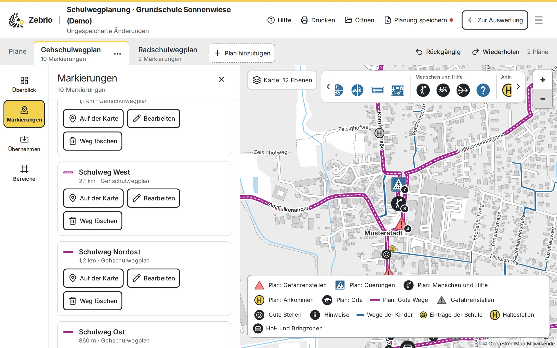
A plan in four steps
Open: from the analysis with “Schulwegplan”, or later with the saved file, also on another computer.
Take over: dangerous spots, good spots, bus stops and drop-off zones from the survey become symbols in the plan with one click.
Draw: recommended routes point by point along the streets, plus symbols such as zebra crossings, crossing guards or meeting points, each with a short description.
Pass on: print the plan as a PDF, save the map as an image or give the data to the municipality and its GIS.
Routes and symbols
Recommended routes
The safe ways to school as a strong line. A route follows the streets from point to point and shows no numbers of children, because it is a recommendation.
Dangerous spots
Dangerous spot, missing pavement, missing crossing aid, extra care needed and roundabout, as in the templates for walking route plans.
Crossings and paths
Zebra crossings, traffic lights, traffic islands and good crossings, pavements, shared paths, one-way streets and traffic-calmed areas.
People and meeting points
Crossing guards, walking bus and cycle bus stops, meeting points and places to get help along the way.
Arrival and places
The school, bus stops, drop-off zones and, for orientation, playgrounds, sports grounds and shops.
Areas
Parts of the village or neighbourhoods get a page of their own in the print, with a closer map and a short description.
Several plans in one planning
A walking and a cycling route plan, a plan for each part of the village, or a second draft to compare: one planning can hold several plans. A copy takes over the symbols, areas and contact person and can then be changed on its own. Every plan says who publishes it and whom parents can ask.
Undo and redo, up to 50 steps
Saved in this browser as you go
Save it as a file and pass it on
What your school route plan could look like
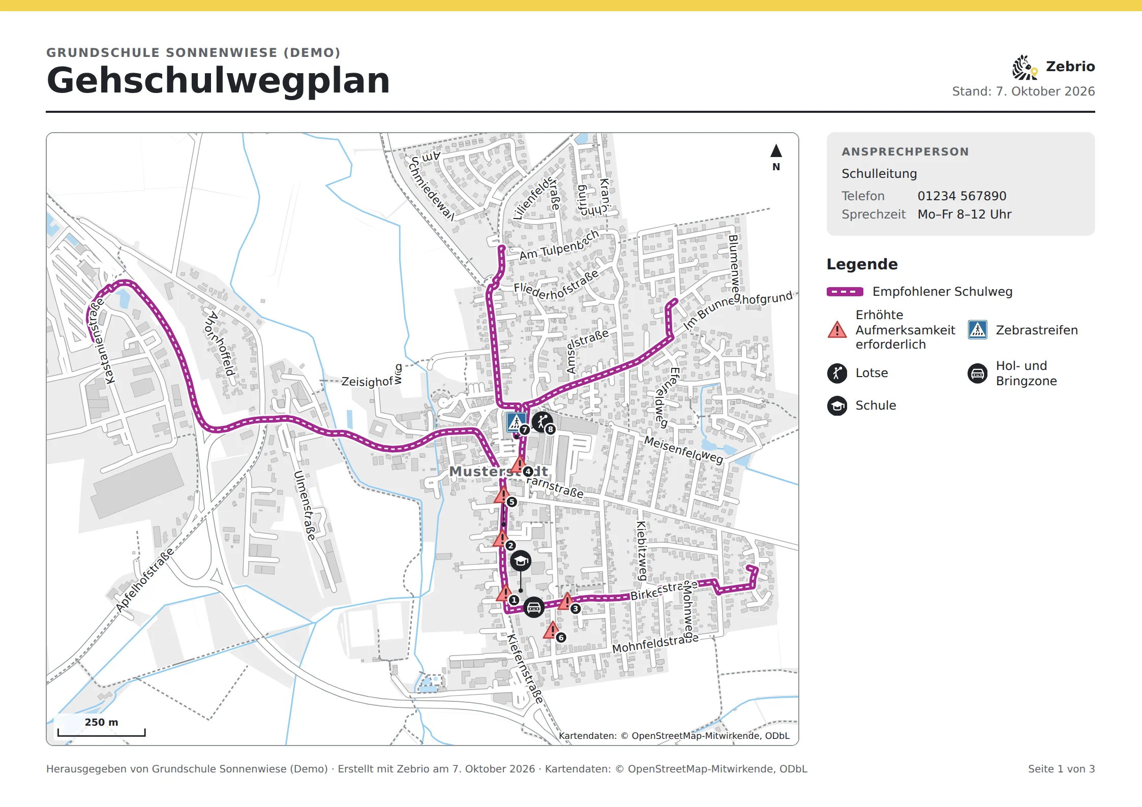
Print, save as an image, pass on
A plan to print
A4 landscape, with an overview map, legend and contact person, a page for each area and the important spots with small maps. Save it as a PDF in the print dialogue.
The map as an image
As SVG or as a high-resolution PNG, for the newsletter, a notice, the website or a layout program.
Data for the municipality
GeoJSON for the GIS, KML for Google Earth, GPX for walking and navigation apps and a table of the symbols for Excel.
Planning file
The whole planning with all its plans and the survey results it is based on. With it, someone can go on planning later, also on another computer.
In the browser, without an account
The planning tool runs entirely in the browser. Nothing of the planning goes to the server, not even when printing or exporting. It contains only summarised survey results, never a single child's route, and needs no key sheet. So the school can pass the planning file on like a report.
Good to know
- No account and no sign-in
- Drafts stay in this browser
- Exports contain only the plan, no single child's route
- The map comes from Zebrio itself, without other services
Try it first
In the demo you play through a school route survey at the invented Sonnenwiese primary school in Musterstadt, from both sides. As a parent you draw a route to school and mark dangerous and good spots. As the school you open the analysis with the key sheet and see the answers of 60 sample families on the map, up to the finished report. So you know beforehand exactly what it means for the school and the parents. You get a personal access for 14 days on request by email. The demo is in German.
As a parent
Draw the route to school, mark dangerous and good spots, send it encrypted.
As the school
The analysis with the map, problem spots, means of transport and the reasons for driving children.
The report
Ready for the municipality and the traffic authority, as a web page, PDF and GIS data.
- From the survey to the planThe whole process: set up, ask the parents, analyse and draw the school route plan.
- Creating a school route planHow a parents' survey provides the basis for the walking and cycling route plan.
- For municipalities and traffic authoritiesReport, maps and GIS data for site inspections and planning.
- Data export and code listsFiles, formats and fields of the exports, with every ID to download.
Zebrio at your school too?
Schools, parents' councils and municipalities that would like to run a school route survey can simply send us an email. We answer your questions and set up the survey for the school.